
Oakzanita (SDC #63, 5054′) • map • directions
Sugg (SDC #66, 5243′) • w/Oakzanita
Viejas (SDC #90, 4189′) • map • directions
Just before 7am in the Green Valley campground, Anna and I crawled out of our sleeping bags and the back of the pickup truck. We were reasonably rested after last night’s hike of Japacha Peak, and didn’t waste much time rolling up the sleeping bags, powering down a bagel and brewing a quick cup of coffee. We packed up and drove ten minutes to the trailhead for Oakzanita, easy to spot with a large turnout, a forest service sign, and a locked gate blocking the East Mesa fire road. We could see the top of Oakzanita from the trailhead, and a lone mountain biker bolted off as we filled our water bottles.
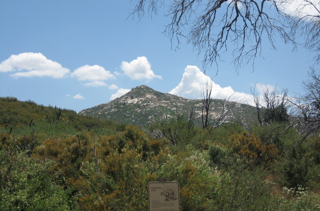
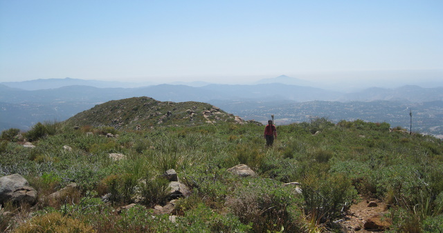
We started off down the fire road and within ten minutes found where the trail breaks off to the right. At the junction, I found a Tom Harrison San Diego Backcountry Recreation map laying in the dirt, the best paper map for finding obscure trailheads in San Diego County. Because of its location I doubted it was the mountain bikers but he was too long gone to ask. We crossed Descanso Creek and followed a trail on its south side before starting the hot and dry ascent up Oakzanita. The trail was easy to follow and gained elevation quickly, before we knew it we were at a saddle just east of the summit. A few short switchbacks and we were at the top, just 45 minutes after leaving the car. The summit was covered in flying red ants, the same I’d seen on the top of Stonewall a while back but in larger numbers here. The ants were so bad we had to find somewhere else to grab a snack.

My eyes were glued to the southeast towards our next objective, Peak 5243. Though only a few miles from the road this area gave me a sense of remoteness, I imagined that not many folks ventured much past Oakzanita.
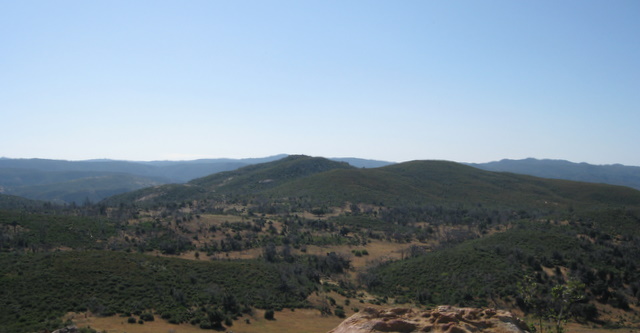
I studied Peak 5243 looking for the best way to get over there, looking like we’d have to do some bushwhacking either way. I saw an old dirt road (marked as a trail on the map) that looked like it ran from near Peak 5243’s summit over a bump on its west side, so we started heading in that direction.
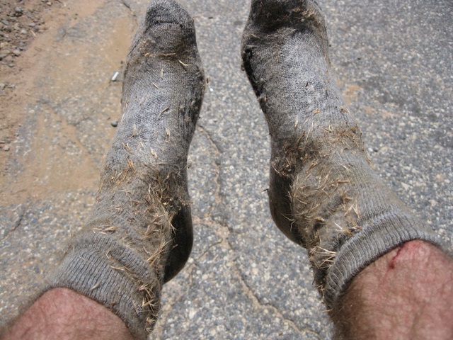
As soon as we left the trail from Oakzanita our socks were loaded with foxtails, and we stopped several times to pull out the worst of them. Pants might have been nice on this part of the hike had it not been so hot. After crossing the foxtail meadow between the two peaks, we started uphill and pushed through pockets of thick vegetation, dodging cactus and other inhospitable plants. It was slow going and fairly brutal in the heat. Just before I expected to reach the old road, we hit an unexpected barbed wire fence. This seemed to be marking the boundary between the Cleveland National Forest and Cuyamaca State Park, both public lands, so I couldn’t understand why the fence was there. We squeezed under the fence and found the road, a nice yet temporary change, we still had some rough bushwhacking on steep ground to reach the actual highpoint. This was some of the worst I’d done to this date. I felt bad for Anna, as last nights hike on Japacha Peak was her first off trail experience, mild compared to this. Nonetheless she stuck it out and we were at the highpoint before too long, along with more flying red ants.
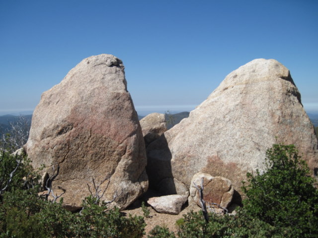
We found an interesting summit log on one of the largef summit boulders and I read through it for a few minutes before searching for an easier way back down to the car. We went north from the summit, aiming for thinner spots of vegetation and crossing the barbed wire fence before turning west to again meet up with the West Mesa fire road. This did prove to be an easier route than our ascent. Soon after reaching the road we found a marked trail (not on our map) that split from the road and seemed to be heading back towards the saddle near Oakzanita so we took the trail. Sure enough ten minutes later we were back on familiar ground. We then retraced our original steps, dropping most of the elevation on the north side of Oakzanita and recrossing Descanso Creek.
Almost near the trailhead, we were stopped by a ranger in a truck. She asked us if we knew where the mountain biker was, apparently there’d been a call for help. I could only assume it was the guy we had seen just before we started our hike, I told her we’d seen a biker at the trailhead a few hours ago and that I hoped he was alright.
By the time we reached the truck we’d been out for just under 4 hours. We were covered in debris from the ascent up Peak 5243 and my socks were so bad I didn’t know if I could use them again. As we were changing I mentioned another possible hike to Anna that we could hit on the way home. Though she didn’t say yes, she didn’t say no either so I figured it would be a go by the time we finished the drive to Viejas.
Viejas
The gate was open near the water tanks on Anderson Road, so we were able to drive right to the trailhead on the west side of Viejas Mountain. I wasn’t sure how easy it was going to be to find the trail since it was supposedly unmarked, but it was obvious and we had no problems seeing it from the road. I set my adventure pass on the dash and threw on some clean socks and shirt while a willing but semi-reluctant Anna put hers pack on. The trail switchbacks steeply from the parking area, gaining 1500 feet in less than 2 miles, and it was hotter here than it was on Oakzanita. The trail was crude in places with sections of loose rock over choppy red and brown hard-packed dirt, though I enjoyed the monotonous yet straightforward ascent.
About halfway up the mountain, I stopped for a few minutes to let Anna catch up and chat with an older woman, I’m guessing was in her mid-50s. She was coming down the trail as happy as can be. Anna and I kept on and seemed to top out so quickly that I failed to take any photos during the actual hike. I’ll have to work on this…
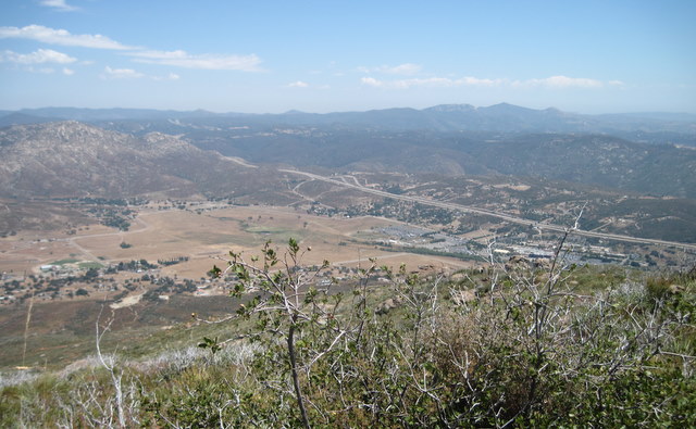
The final 1/4 mile to the summit is relatively flat along a broad ridge and the views really open up here. I tried not to notice, hoping to save it all for the true highpoint. We spent a few minutes scrambling over some easy piles of rock and and were at the summit in no time, 65 minutes from the car. The views were impressive, affording seemingly infinite vistas in all directions. I’m not sure if there’s anything higher to the west in San Diego and I promised myself I’d come back on a clearer day.

It didn’t take too long to get back down to the truck, making the roundtrip in two hours flat. Pretty fast considering the elevation gain/loss but reasonable considering that’s thirty minutes per mile. Like I said before, perfect training mountain.
We stopped by a greasy burger joint in Alpine on the way out hoping that no one would notice our impressive dirt-tans and Anna was happy we’d done that last hike, now that it was over…
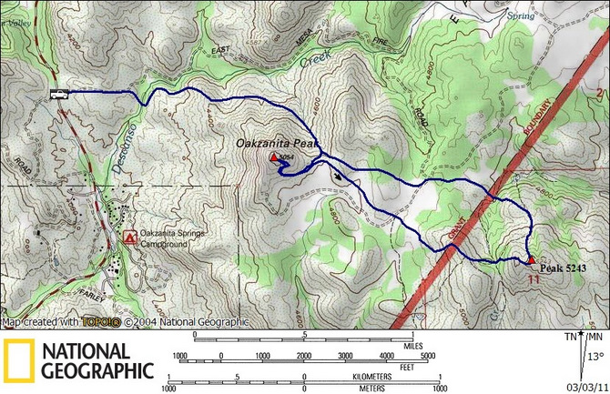
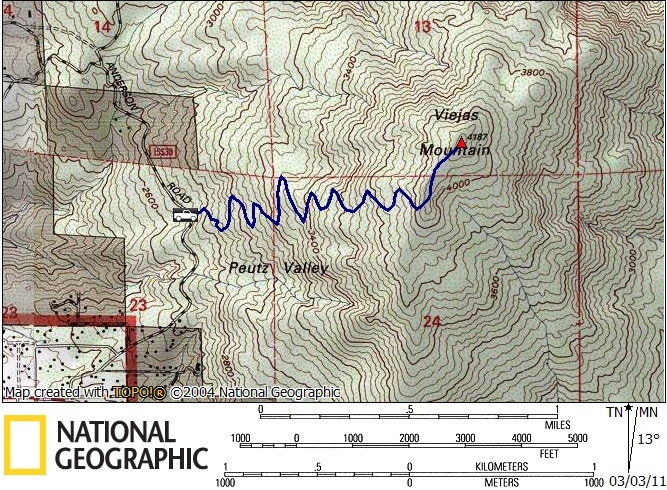
Note: switchbacks on map are not accurate